ModRana
(→Resources) |
|||
| (7 intermediate revisions not shown) | |||
| Line 38: | Line 38: | ||
* ''result can be saved as a GPX tracklog'' | * ''result can be saved as a GPX tracklog'' | ||
* multilingual (English, Czech, Russian, ''Chinese'', Spanish, German, ...) | * multilingual (English, Czech, Russian, ''Chinese'', Spanish, German, ...) | ||
| + | |||
| + | '''offline routing''' | ||
| + | * searches for routes without the need for Internet connection | ||
| + | * routing is much faster than online routing | ||
| + | * mode based results (Car, Walk, Cycle; Bus & Train get results for Car) | ||
| + | * uses monav-server as backend | ||
| + | * directions are currently quite basic | ||
| + | * see the [[ModRana_offline_routing_guide|modRana offline routing guide]] for more information | ||
| + | |||
'''Turn-by-turn navigation with voice directions''' | '''Turn-by-turn navigation with voice directions''' | ||
* turn description shown per-turn with big friendly letters | * turn description shown per-turn with big friendly letters | ||
| Line 116: | Line 125: | ||
* [[Navigation Tools]] | * [[Navigation Tools]] | ||
| - | + | * [http://wiki.maemo.org/Setting_modrana_to_use_voice_navigation_with_mbrola How to set up modrana to use the mbrola high quality voice navigation] | |
| + | * [http://wiki.maemo.org/ModranaOsmTagsForSearchPresets OSM tag mapping for modRana search presets] | ||
[[Category:N900]] | [[Category:N900]] | ||
| + | [[Category:N9]] | ||
| + | [[Category:N950]] | ||
[[Category:Software]] | [[Category:Software]] | ||
[[Category:GPS]] | [[Category:GPS]] | ||
| + | [[Category:ModRana]] | ||
Latest revision as of 23:03, 20 January 2015
Contents |
[edit] Feature overview
GUI
- big, finger friendly buttons
- automatic landscape/portrait rotation
map display
- from map tiles
- semi-transparent layer-over-layer overlay is supported
- map scaling (2X, 4X)
- automatic map rotation
tile download
- automatic (can be turned off)
batch tile download
- current area, area currently shown on map, area around a tracklog
- radius and zoomlevel range can be set
- fully threaded, can be run in background, completion is signalized by a notification
tile storage
- compatible with TangoGPS
- optional sqlite tile storage (massive space savings)
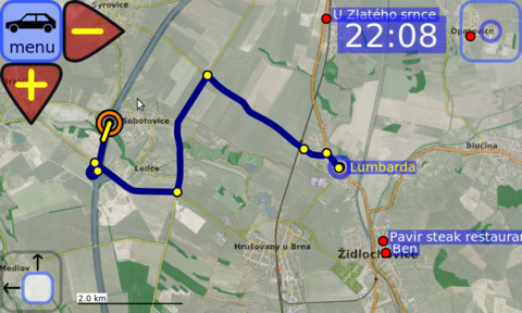
online routing
- using Google Directions
- Point2Point, Adress2Address, to POI, Combined
- detailed route info
- result can be saved as a GPX tracklog
- multilingual (English, Czech, Russian, Chinese, Spanish, German, ...)
offline routing
- searches for routes without the need for Internet connection
- routing is much faster than online routing
- mode based results (Car, Walk, Cycle; Bus & Train get results for Car)
- uses monav-server as backend
- directions are currently quite basic
- see the modRana offline routing guide for more information
Turn-by-turn navigation with voice directions
- turn description shown per-turn with big friendly letters
- navigation info box can by hidden into a button
- voice directions work even when the screen is off
- voice output can be turned off
- power-users can edit voice parameters using the "manual" mode
tracklogs
- in GPX format
- optimized track display
- route elevation profile
- elevation data download from Geonames
track logging
- configurable
- statistics
- directly to GPX
online POI search
- using Google Local Search
- search for ATMs, Pizza, WiFi, Landmarks, EV charging stations, etc.
- addresses and telephone numbers for results
- around current position, live distance display
- custom query support
POI
- you can save as a POI:
- your current position
- a point on the map
- local search results
- manually entered coordinates
- easily accessible routing from current position to POI
- easy stored POI modification
- categories
- CSV export
configurable UI
- configurations are per mode (bike,car,bus,walking,train,etc.)
- size and position of all UI elements can be customized
- using the main config file
- interactive configuration <- PLANED
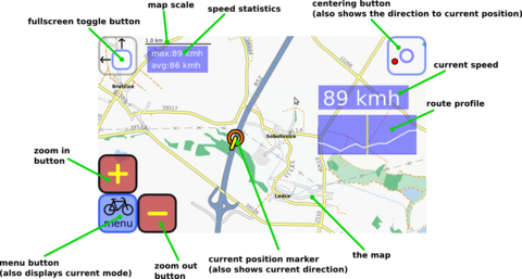
information widgets
- semi transparent
- time, speed, stats, coordinates, route profile, distance remaining, etc.
- also per mode
- same config
- also should be interactively configurable in the future
[edit] Roadmap
See the roadmap wiki page for the current modRana roadmap. In short, the main item on the current roadmap is a new Qt based GUI, in addition to the current GTK based one.
[edit] Supported devices
[edit] Maemo 5 @ N900
ModRana is conveniently available directly from the location&navigation category in Extras-Devel.
[edit] MeeGo 1.2 @ N9,N950
Porting to Harmattan is a work in progress - see the roadmap for more info. It is already possible to run modRana with the currently available GTK GUI but it should be much more usable once the Qt based GUI is in a usable state.
[edit] SHR @ OpenMoko Neo FreeRunner
ModRana also runs on this good-old open hardware smartphone, get packages from the Neo download section.
[edit] Manual installation
First make sure you have the core dependencies:
- Python 2.5+
- GTK
- CAIRO
- PyGTK
There are also some optional dependencies that modRana will use if available:
- espeak - for voice output
Then download the tarball, unpack it somewhere and run the modrana.py file. You can make modRana use a specific device module by suppliing a command line argument:
- neo - modRana will use the Neo FreeRunner device module
- n900 - modRana will use the N900 device module
- android_chroot - modRana will use the device module for Android chroot
[edit] Resources
- modRana source code repository [github.com]
- modRana project homepage [modrana.org]
- modRana thread on talk.maemo.org [maemo.org]
- unofficial download statistics
- This page was last modified on 20 January 2015, at 23:03.
- This page has been accessed 36,696 times.


